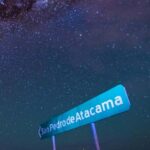
REVIEW · SAN PEDRO DE ATACAMA
From San Pedro de Atacama: The Salt Flats Route, Full day
Book on GetYourGuide →Operated by Ruta Chile · Bookable on GetYourGuide
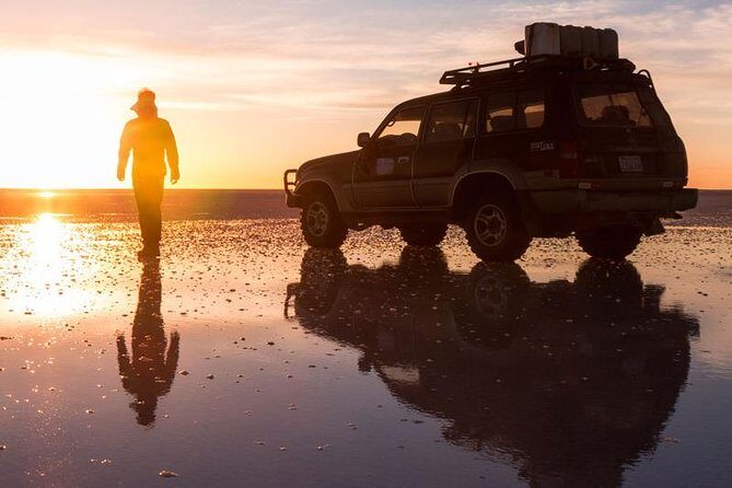
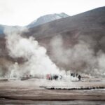
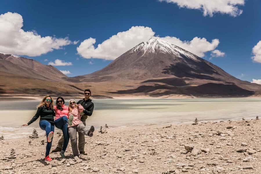
If you like big sky and stranger-than-fiction geology, this Salt Flats Route delivers from start to finish, with Licancábur volcano dominating the horizon and flamingos chilensis making the salt lakes feel alive. I especially liked how the drive mixes dramatic stops with quick chances to look, listen, and photograph before the van moves on. One drawback to plan for: the altitude is real, and your experience depends on how your body handles long stretches above 4,000 m.
I also like the straightforward format: shared pickup in San Pedro, a bilingual guide, and a built-in breakfast and snack so you’re not scrambling at high altitude. The route runs along the Paso de Jama area and includes border control, so it has more of that “real journey” feel than a simple parking-lot tour.
Before you book, check if the trip fits your health and energy level. This one isn’t recommended for children under 10, pregnant women, or people with high blood pressure, and you’ll be spending time far above sea level.
In This Review
- Key points you’ll care about
- From San Pedro to Paso de Jama: the climb that sets the mood
- Licancábur at 5,916 m: why that volcano is the star
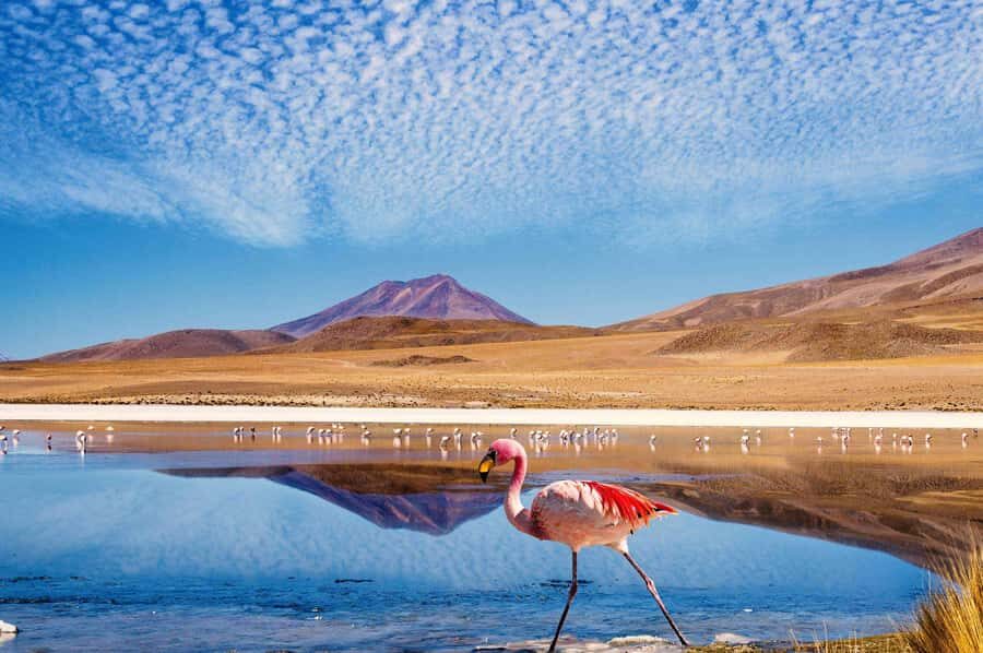
- Ostriches, small lakes, and flamingos chilensis on the way
- Pakana hills and the Farellón of Tara: the Moai of Tara story
- Cathedrals of Pakana and Salar de Tara at about 4,500 m
- Altitude, comfort, and why the pacing matters
- Price and value: what $78 really covers
- Guide quality: what to look for in Spanish and English
- Who should book this Salt Flats Route (and who shouldn’t)
- Should you book? My practical recommendation
- FAQ
- How long is the Salt Flats Route from San Pedro de Atacama?
- What time does the tour depart from San Pedro de Atacama?
- Is pickup from hotels included?
- What languages does the guide speak?
- What’s included in the price?
- What should I bring for the tour?
- Is this tour suitable for children or pregnancy?
- Do I need tickets included in the price?
Key points you’ll care about
- Licancábur (5,916 m) views from a high-altitude crossing point along the route
- Paso de Jama border route with panoramic stops over Salar de Atacama and the San Pedro oasis
- Altiplano wildlife sightings on the drive, including ostriches and flamingos in small lakes
- Pakana geology stops like the Farellón of Tara and the Moai of Tara rock formations
- Salar de Tara at ~4,500 m with salt-lake ecosystem vibes and lots of bird activity
- Shared transport pacing means a good experience if you can handle frequent getting in and out
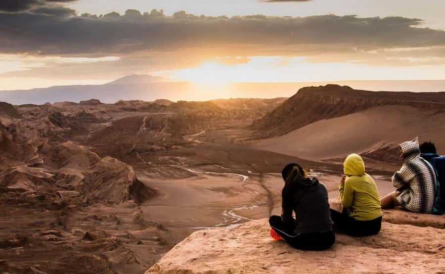
From San Pedro to Paso de Jama: the climb that sets the mood
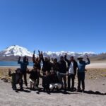
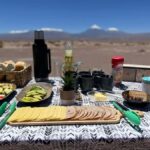
The day starts with an 08:00 departure from your hotel in downtown San Pedro de Atacama. It’s shared transportation, so you’ll likely meet other people from nearby accommodations and get sorted quickly. You’ll also have breakfast and a snack built into the plan, which matters because once you’re higher up, you won’t want to be hungry while the van keeps climbing.
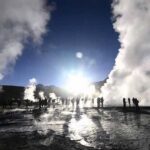
Early on, the route works like a slow-moving viewpoint. You head toward the Paso de Jama area and pass through Chilean border control. The road isn’t just paved and pretty—it climbs on slopes formed by lava and ash, which is one of those small details that makes the place feel honest. You’re not only visiting scenery. You’re traveling through the land that created that scenery.
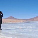
As you go higher, the stops make sense: you get panorama views across the Salar de Atacama and the Oasis of San Pedro de Atacama. Even if you’ve already seen photos online, seeing the basin from the road gives the salt flat scale a new feel. One minute it looks like a blank surface; the next, you realize it’s an entire ecosystem shaped by water that arrives, disappears, and reappears.
Practical note: bring your passport or ID card. Since the route includes border control, you don’t want to start the morning solving paperwork problems.
A few more San Pedro De Atacama tours and experiences worth a look
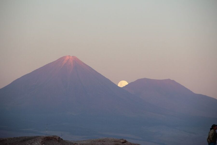
Licancábur at 5,916 m: why that volcano is the star
Licancábur is the reason many people choose this day trip, and the route is designed to put it in your line of sight. Around km 41, at roughly 4,200 m altitude, you reach a key crossing point (the route mentions Hito Cajón north of Licancabur). This is where the mountain becomes more than a distant outline—it feels close enough to study.
Here’s what I think you’ll appreciate: the guide doesn’t just point at the peak. The emphasis is on altitude and location. When you’re standing in the altiplano air, you understand why Licancábur is so visually commanding even without zooming a camera lens.
You also get a feel for the volcanic terrain. The climb along lava-and-ash slopes leads naturally into thinking about how these highlands formed. If you’re even casually interested in geology, this part of the day is the hook that connects the later rock-formation stops into one bigger story.
Ostriches, small lakes, and flamingos chilensis on the way
The route keeps an eye on wildlife, not just rocks. It’s common to see groups of ostriches while you’re moving between stops, especially in open stretches where the altiplano looks flat but still feels alive.
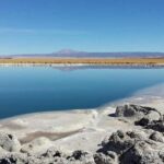
Then there are the small lakes mentioned along the way (around km 75). This is where the birdwatching payoff kicks in. The tour highlights flamingos and other birds using these water spots, and it’s a good reminder that the desert is not empty. It’s just selective about what it can support.
If you want to maximize this part of the experience, keep your pace calm. Altitude can make you feel light-headed, and when you rush, you miss small movements—like a bird lifting its head, or a sudden flock shift. Instead, slow down at each stop. Give your eyes a minute to adjust, and you’ll notice more than you would if you were only chasing the biggest view.
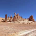
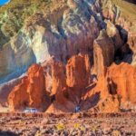
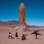
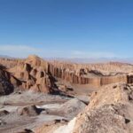
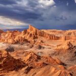
Pakana hills and the Farellón of Tara: the Moai of Tara story
Around km 91, the route moves through the hills of Pakana and then toward the Farellón of Tara. This is where the trip turns from “scenery” into “wow, how did that happen?”
The Farellón of Tara is described as a rock wall carved with sculptures. The key feature is the Moai of Tara—also referred to as the Pakana Witness. Instead of a neat, museum-style exhibit, you’re looking at natural rock structures that have been preserved across geological time. The tour explanation ties them to violent volcanic events during the Tertiary period, leaving behind columns and formations that act like evidence you can walk near.
This stop is valuable because it gives you a way to interpret the place. Salt flats are usually easy to understand visually, but these rock formations can seem random unless someone frames them. A good guide does that framing—and on this route, bilingual guides are part of the package, so the explanation can land even if you’re not fluent in Spanish.
One word of advice: ask questions when you have the chance. If you’re unclear on the timing or what you’re looking at, you’ll get more from the stop by speaking up right away, not later when the van is rolling again.
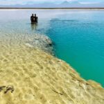
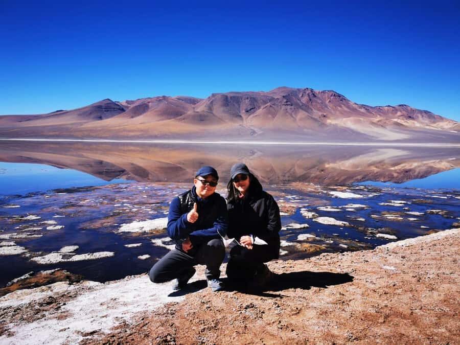
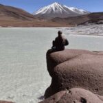
Cathedrals of Pakana and Salar de Tara at about 4,500 m
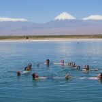
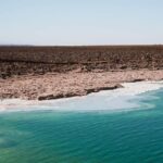
Near the end of the route, you arrive at the Salar de Tara at roughly 4,500 meters. This is the segment many people are excited about because it pairs “salt flat” visuals with real ecosystem hints—especially bird activity. The tour notes that flamingos chilensis are among the most common birds you can see here.
This is also the altitude challenge phase. By the time you reach 4,500 m, you’re likely feeling it in breathing and energy levels, even if you’re used to traveling in the Andes. The good news is that this part of the day gives you something tangible to focus on: the salt lake surface, the surrounding tones, and the birds using the water. It’s the kind of setting where time feels slower because you want to keep looking.
A practical consideration: while the plan includes Salar de Tara, the actual time and how fully you reach each element can depend on the day’s flow and group positioning. If Salar de Tara is the top reason you booked, it’s smart to confirm with the operator how much time you’ll have there and whether your schedule will include that full stop.
Altitude, comfort, and why the pacing matters
This is a 6-hour tour, so it’s not slow—but it isn’t a sprint either. The route includes multiple viewpoints and structured stops, and shared transport means you may get in and out many times during the day. That can be tiring even for people who feel fine at sea level.
There are a couple health realities to respect. The activity isn’t suitable for pregnant women or for people with high blood pressure, and children under 10 aren’t recommended. If you’re unsure, it’s worth talking to your doctor before you go, because this day is built around high-altitude zones (including points around 4,200 m and the salar at about 4,500 m).
What I’d do in your shoes: treat this as a body-first day. Take your time at each stop, breathe slowly, and don’t try to power through if you start feeling off. If you’re with a group and you can’t hear questions clearly, speak up during the next pause so the guide can respond while you’re still on the same subject.
One more comfort tip from real-world experience on this kind of route: keep your expectations flexible. Altitude affects people differently. If you’re going to be sensitive to that, aim for a calmer mindset, not a checklist mentality.
Price and value: what $78 really covers
At $78 per person for about 6 hours, the value comes from a few specific things you’d otherwise pay for separately.
You get:
- pickup from downtown San Pedro de Atacama (shared transportation)
- a bilingual guide (Spanish and English)
- breakfast and a snack
Tickets are not included, and meals beyond the provided food aren’t specified. So, yes, you should plan for additional eating options before or after the tour, and it helps to know you’ll be relying on that included breakfast/snack while you’re at altitude.
Where the money feels well spent is in the structure. You’re not just driving to one salt-flat viewpoint. You’re moving through multiple natural features—border route panoramas, volcano viewing, wildlife zones, and rock formations—under the guidance of someone who can explain what you’re seeing.
Is it the cheapest way to visit? Possibly not. But it’s often a strong deal compared with private transport or piecing together separate guides for each stop, especially when you factor in border control logistics and interpretation.
Also keep an eye on booking options: the activity offers free cancellation up to 24 hours in advance for a full refund, and it’s marketed with reserve now & pay later flexibility. That kind of flexibility can matter in the Atacama, where weather and altitude feel can change your schedule.
Guide quality: what to look for in Spanish and English
The tour includes a live guide in both Spanish and English. In one standout case, the guide named Pedro received strong praise for being first class and for keeping the group engaged.
That said, this kind of bilingual touring depends on timing, spacing, and where you sit in the vehicle. If your seat choice makes it hard to hear explanations and questions, you’ll get less out of the “live” part even if the guide is excellent. If you can choose your spot in the van, try to position yourself where you can hear comfortably.
For English-only speakers, you’ll also benefit from being proactive. When the van stops, don’t wait for perfect conditions—ask what you want to know right then. You’ll learn more in a brief exchange at a viewpoint than you will if you wait for something you might only partially catch.
Who should book this Salt Flats Route (and who shouldn’t)
This tour is a good match if you:
- want Licancábur views without needing a full mountaineering plan
- care about altiplano wildlife like ostriches and flamingos
- enjoy geology and rock formations, not just wide open salt views
- can handle time at roughly 4,000–4,500 m
It’s not a good match if you’re:
- under 10 years old
- pregnant
- dealing with high blood pressure
If you’re someone who gets winded easily at altitude, take that seriously. Don’t just think about whether you can stand there for a minute; think about how you’ll manage 6 hours of changing elevation and repeated stops.
Should you book? My practical recommendation
Book this Salt Flats Route if you want a high-altitude day with real interpretation—volcano viewing, birdlife, and unusual rock formations—without the stress of managing multiple logistics yourself. The structure is what makes it work: you travel, you stop, you learn, you watch birds and salt flats, and you’re done in time to recover in San Pedro afterward.
Don’t book it blindly if you’re worried about hearing the guide well or if Salar de Tara is your single biggest must-see. In that case, confirm before you go how much time you’ll spend at the salar stop and whether the route includes it as fully as you expect.
If you’re healthy enough for altitude, this is one of those days in northern Chile where the place feels bigger than the photos. It’s not just a salt flat tour—it’s a border-route, volcano-frame, altiplano-bird day.
FAQ
How long is the Salt Flats Route from San Pedro de Atacama?
It lasts about 6 hours.
What time does the tour depart from San Pedro de Atacama?
The departure is listed as 08:00 from your hotel.
Is pickup from hotels included?
Yes. Pickup is included from hotels, apartments, and accommodation in downtown San Pedro de Atacama.
What languages does the guide speak?
The guide provides live commentary in Spanish and English.
What’s included in the price?
Shared hotel pickup, a bilingual guide, and breakfast plus a snack are included.
What should I bring for the tour?
Bring your passport or an ID card.
Is this tour suitable for children or pregnancy?
It is not suitable for children under 10, pregnant women, or people with high blood pressure.
Do I need tickets included in the price?
Tickets are not included. Other meals and drinks beyond the provided food are also not included as specified.
—
If you want, tell me your travel dates and whether your top goal is Licancábur views, flamingos, or the rock formations. I can help you decide if this is the right fit for your priorities and comfort level.